Global Witness Data Study Group
Welcome
Welcome to the GitHub repository for the Global Witness Data Study Group at the Alan Turing Institute. The purpose of this project is to identify unregulated mining sites of critical minerals in Myanmar using historical satellite imagery and machine learning.
Background
China has long dominated the world’s supply of heavy rare earths, minerals needed to build electric vehicles and wind turbines. Demand for these products is skyrocketing as we rush to meet climate goals, but there is a problem at the root of the supply chain.
The processes used to extract heavy rare earths are highly polluting, ravaging landscapes and poisoning waterways. Move the slider below to compare satellite imagery showing the proliferation of these mines since 2016:
As concerns over the environmental toll of extraction have grown in China over the past decade, more and more domestic mines have been shut down. Yet global demand is growing rapidly, and China remains the world’s largest processor. But with many of its own mines closed, China has turned to neighbouring Myanmar to fulfill demand. In 2014, Myanmar exported just $1.5m of rare earths to China. By 2021, this sum had reached $740m.
Global Witness’ recent press release highlights some of the catastrophic impacts that unregulated mining has on the environment and people’s health, where the pollution caused by seeping chemicals into water bodies could take up to 100 years to clean-up. Global Witness has conducted extensive primary research on the subject, and found that may villagers in the area struggle to find clean drinking water. Such environmental impacts not only threaten the health and livelihoods of current generations of local residents, but those of future generations as well. The identification of these sites is a natural prerequisite for the clean-up of the pollution they cause.
The overall aim of this project will be to accomplish the following three goals:
- Identify artisanal mines on the basis of satellite imagery.
- Quantify the level of activity at each mine using variability of pool colour.
- Identify areas that are at risk of mining based on geographic suitability.
Data
Historical locations of unregulated mines
(CSV of coordinates, available in the TRE)
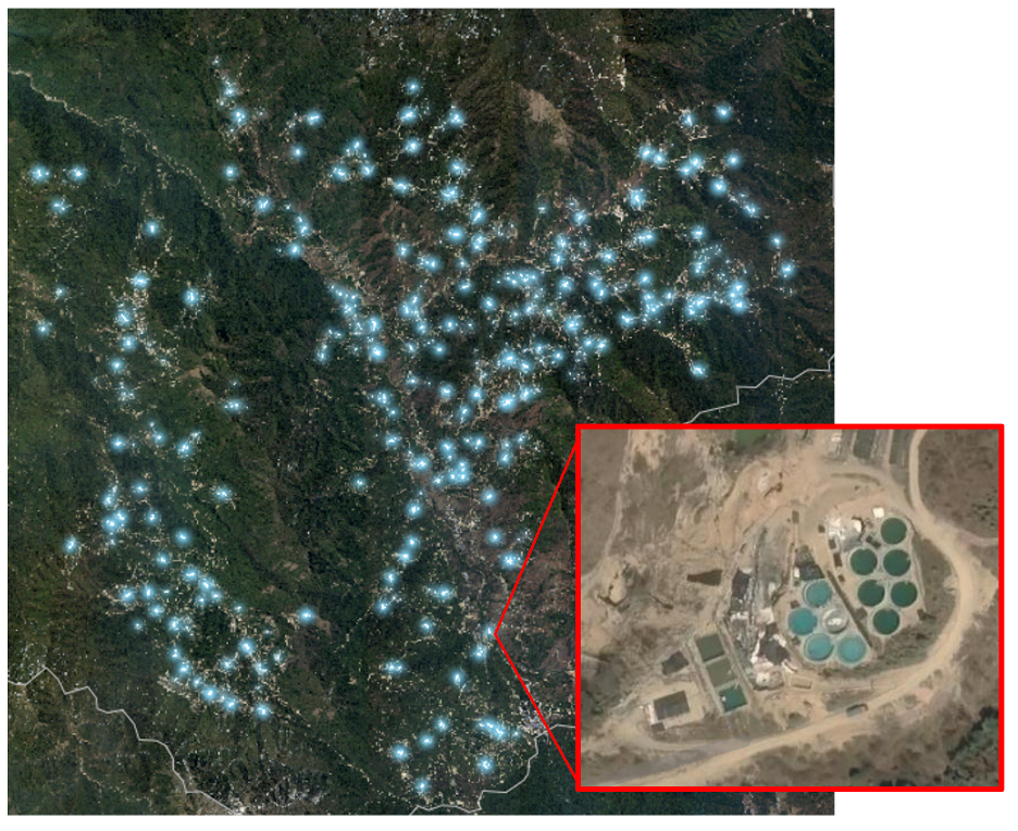
The coordinates of 2,700 artisanal mines were collected manually by Global Witness. The inset satellite image shows a close-up of one such mine; bright blue “precipitation pools”—used to precipitate out minerals from a slurry of ammonium sulphate and mud— are a characteristic feature of such mines. Runoff from these pools leech directly into the N’Mai Kha river, which runs the length of Myanmar and whose basin is home to 2/3 of the country’s population.
The timelapse of PlanetScope imagery above shows the proliferation of artisanal mines just north of Pang War, a town on the Chinese border. The relatively high spatial resolution of PlanetScope imagery enables the use of methods such as object detection. For example, by creating a square buffer around the coordinates of each mine identified by Global Witness, a Convolutional Neural Network such as YOLOv8 could be trained to identify new mines in more recent imagery, or mines outside of the study area surveyed by Global Witness.
High-resolution satellite imagery
(Planet SkySat, 50cm/pixel, available in the TRE)
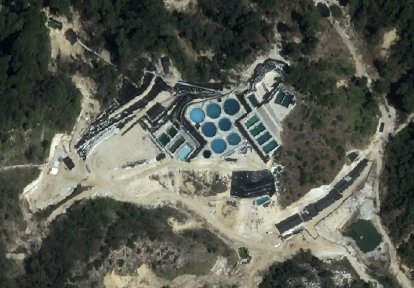
Global Witness tasked Planet’s high resolution SkySat satellite to collect imagery over this region of Myanmar. This was the imagery used to manually identify the mines. Below is a close-up image of one such mine:
Low-resolution optical satellite imagery
(Sentinel-2, 10 meters per pixel, available from ESA)
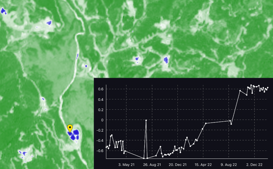
Despite its relatively low spatial resolution, multispectral satellite imagery from the European Space Agency’s Sentinel-2 satellite allows for the differentiation of materials such as water and vegetation on the basis of their spectral reflectance characteristics. The calculation of spectral indices—such as the Normalized Difference Water Index (NDWI)—highlights the pools used for the extraction of minerals in artisanal mines in Myanmar. The inset line plot shows the NDWI value measured at the location of the yellow marker over time; though there is some noise, the measured point achieves sustained positive NDWI values after August 2022.
Sentinel-2 imagery is free and publicly available, with an extensive imagery archive going back to 2015. Pixel-based classification methods, such as the Continuous Change Detection and Classification method, could be applied to detect not only the presence of such artisanal mines, but the rough timing of the mine’s construction.
Medium-resolution satellite imagery
(PlanetScope, 3 meters per pixel, available with API Access)
The timelapse of PlanetScope imagery above shows the proliferation of artisanal mines just north of Pang War, a town on the Chinese border. The relatively high spatial resolution of PlanetScope imagery enables the use of methods such as object detection. For example, by creating a square buffer around the coordinates of each mine identified by Global Witness, a Convolutional Neural Network such as YOLOv8 could be trained to identify new mines in more recent imagery, or mines outside of the study area surveyed by Global Witness.